JACKSON, Miss. (Special) — The Disaster Relief Department at the Mississippi Baptist Convention Board is cautioning the state’s residents to prepare for an approaching weather system that could unleash dangerous, large-scale conditions as it moves through the southeast U.S.

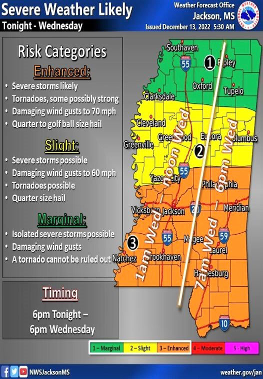
“The National Weather Service (NWS) and Mississippi Emergency Management Agency (MEMA) are advising residents of the state of the potential for a severe weather event developing late this afternoon/evening (Tuesday) and extending overnight and throughout the day tomorrow (Wednesday),” said Hubert Yates, MBCB disaster relief director
“All forms of severe weather are possible including tornadoes, high winds, heavy rain, hail, and flash flooding. Already this (Tuesday) morning, tornado watches and warnings have been posted in west central Texas and central Oklahoma,” he said.
According to NWS, storms will begin to cross the Mississippi River from Louisiana between 11 p.m. and 1 a.m. on the evening of Dec. 13 and the morning of Dec. 14. A squall line is expected to stall across the Natchez Trace Corridor (Natchez-Jackson-Ackerman-Tupelo) during the early morning and day on Wednesday.
The system will then move through the state from west to east, ending in the west around noon on Dec. 13 and exiting the state to the east around 6 p.m. on Dec. 14. This final push may be accompanied by the redevelopment of severe storms along the frontal boundary as it passes through the state.
“With all forms of severe weather a possibility, Mississippi Baptist Disaster Relief is on standby to assist with cleanup and recovery operations,” Yates reported.
Mississippi Baptist Disaster Relief is supported by gifts to the Mississippi Cooperative Program, the Margaret Lackey State Missions Offering, and donations. For more information and to volunteer, contact Yates at hyates@mbcb.org. Telephone: (601) 292-2335.