By Hubert Yates
MS Disaster Relief Director
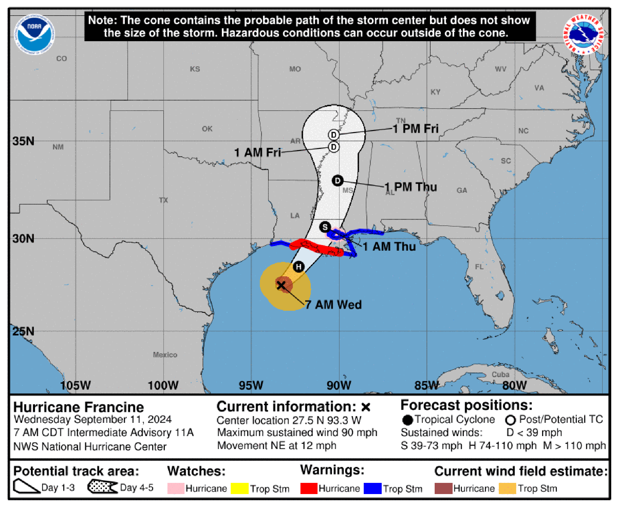
With the 7:00 a.m. National Hurricane Center (NHC) update, Hurricane Francine has now strengthened to a CAT1 hurricane with winds approaching 90 mph. Some slight strengthening is expected this morning with landfall along the Louisiana Coast between Vermillion Bay and Grand Isle (Morgan City area) late this afternoon/early evening possibly as a low CAT2 strength storm. Rapid weakening of the storm is expected as it makes landfall with tropical storm conditions expected as it moves into SW Mississippi and northward overnight and into the day on Thursday before exiting the state in the Memphis area late Thursday. The track has shifted slightly east again but still remains along the I-55 Corridor. The majority of the effects will be to the east side of the storm track.
This is what to expect:
Gulf Coast Counties — Storm Surge (4-6 feet for Hancock/3-5 feet for Harrison and Jackson Counties) coupled with high tides may cause coastal flooding to low lying areas. Rains of 8-12 inches can be expected beginning early afternoon and intensifying as the evening approaches. Winds will increase through today with tropical storm force gusts expected later this morning and sustained late this afternoon. Weather should begin clearing tomorrow morning with times of rain/gusty winds as feeder bands continue to rotate and the system moves further north in Mississippi. Power outages should be expected. (TIMING: Noon through early Thursday morning)
Southwest Mississippi, Jackson Metro, Pine Belt, East Central MS, Golden Triangle Counties, Northeast Mississippi, Memphis Metro — Heavy rains of 4-6 inches beginning late this afternoon in the southern areas and progressing northward through the day tomorrow. Some local areas may receive higher amounts. Strong winds (higher south of the I-20 corridor) with gusts of 30-45 mph through the night and early Thursday morning. Some flash flooding possible and downed trees/power lines are to be expected. System should gradually clear from the south beginning Thursday morning and exit the state in the north early Thursday evening. (TIMING: Progressing northward beginning in SW this afternoon and early Thursday morning for NE; ending early Thursday morning for SW and Thursday night for NE)
Mississippi Delta — Rains of 2-4” with gusty winds less than 45mph. Some minor flash flooding may be experienced in some of the stronger storms associated with the system. (TIMING: Overnight Wednesday through the day on Thursday, may be intermittent)
The threat of tornadoes is minimal for East Central Mississippi with the Pine Belt and Mississippi Gulf Coast listed by the National Weather Service in the SLIGHT Risk (2/5) category. Tornadoes are expected to be brief spin up tornadoes that are often associated with a tropical system event.
All Mississippi Baptist Disaster Relief (MSBDR) volunteers and teams have been placed on ALERT status in preparation for the storm. We are available to assist you if the need arises. For those of you who have teams in your association/counties, reach out to your team leads if you become aware of a local need.
Please report damage/needs to the MSBDR Office by contacting Hubert Yates at hyates@mbcb.org or 601-292-3335. MSBDR is also on ALERT to support Louisiana Baptist Disaster Relief once we clear the state of Mississippi of response needs.


